The Ultimate 2026 Guide to the Bahria Town Rawalpindi Map Navigation, Investment, and Accessibility
Understanding the vast real estate landscape of the Twin Cities requires more than just market sentiment; it requires precise geographical intelligence. Whether you are a family searching for a turnkey luxury villa or a strategic investor looking to capitalize on high-yield commercial sectors, the Bahria Town Rawalpindi Map is your most critical tool. In 2026, with monumental infrastructure projects fundamentally shifting property values, knowing how to accurately read and utilize the Bahria Town Rawalpindi Map is the defining factor between an average property purchase and a highly lucrative, generational investment.
About Bahria Town
The Ultimate 2026 Guide to the Bahria Town Rawalpindi Map
Understanding the vast real estate landscape of the Twin Cities requires more than just market sentiment; it requires precise geographical intelligence. Whether you are a family searching for a turnkey luxury villa or a strategic investor looking to capitalize on high-yield commercial sectors, the Bahria Town Rawalpindi Map is your most critical tool. In 2026, with monumental infrastructure projects fundamentally shifting property values, knowing how to accurately read and utilize the Bahria Town Rawalpindi Map is the defining factor between an average property purchase and a highly lucrative, generational investment.
For years, buyers and agents relied on outdated, static, and blurry paper maps. Today, the scale of this master-planned mega-city demands a modern approach. At ilaaqa.com, we understand that serious investors need exact coordinates, topographical data, and real-time development updates. By utilizing high-resolution, georeferenced map tiles, a modern digital Bahria Town Rawalpindi Map allows you to zoom directly into specific streets, analyze plot categories, and verify commercial proximities with absolute certainty.
This comprehensive guide will decode the Bahria Town Rawalpindi Map phase by phase, analyze the 2026 accessibility updates including the Rawalpindi Ring Road, and map out the neighboring societies that influence this region’s immense real estate value.
Explore Bahria Town by Phase: Find Your Perfect Sector
In the past, real estate transactions were often conducted blindly. A buyer would look at a flat piece of paper, point to a colored square, and make a multimillion-rupee decision. In 2026, the real estate market has evolved. The topography of Rawalpindi is naturally undulating, meaning a plot that looks perfectly flat on a standard 2D drawing might actually require expensive earth-filling or retaining walls in reality.
Why You Need a Digital, Georeferenced Bahria Town Rawalpindi Map
In the past, real estate transactions were often conducted blindly. A buyer would look at a flat piece of paper, point to a colored square, and make a multimillion-rupee decision. In 2026, the real estate market has evolved. The topography of Rawalpindi is naturally undulating, meaning a plot that looks perfectly flat on a standard 2D drawing might actually require expensive earth-filling or retaining walls in reality.
This is where an interactive, georeferenced Bahria Town Rawalpindi Map changes the game. By overlaying exact societal master plans onto real-world satellite imagery using advanced GIS (Geographic Information System) technologies, investors can now conduct virtual site visits.
When you access a high-fidelity Bahria Town Rawalpindi Map, you are not just looking at plot numbers. You are looking at the exact width of the street, the walking distance to the nearest Jamia Mosque, the alignment of the plot relative to the sun (a crucial factor for construction in Pakistan), and the precise distance from major commercial boulevards. For a market that operates on speed and accuracy, a digitized Bahria Town Rawalpindi Map is the ultimate competitive advantage for the modern buyer.
Decoding the Phases: A Breakdown of the Bahria Town Rawalpindi Map
To truly master the local real estate market, you must understand the geographical flow of the society. The Bahria Town Rawalpindi Map is practically a map of a small, independent city, divided into distinct phases, each offering a unique lifestyle and investment timeline.
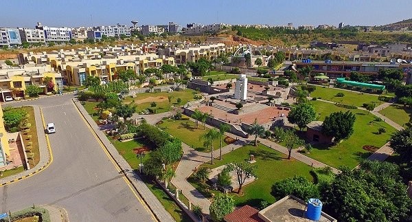
Phases 1 to 6: The Settled Heart on the Bahria Town Rawalpindi Map
When you look at the eastern edge of the Bahria Town Rawalpindi Map, you will find Phases 1 through 6. These are the foundational blocks of the society. Tucked away near the PWD Housing Society and the Soan River, these sectors represent the mature, fully settled heart of the community. On the Bahria Town Rawalpindi Map, Phases 1 to 6 are characterized by their dense green canopies, winding roads that follow the natural topography, and a highly active community footprint. Because these areas are 100% developed, analyzing the Bahria Town Rawalpindi Map for these phases is mostly about finding resale homes rather than raw land. The map highlights key operational amenities here, such as the Safari Club, the Arena Cinema, and established educational institutions like Roots Millennium Schools.
Phase 7: The Connecting Hub on the Bahria Town Rawalpindi Map
Moving geographically westward, the Bahria Town Rawalpindi Map reveals Phase 7. This phase acts as a crucial bridge connecting the older, settled phases to the sprawling modern infrastructure of Phase 8. On the Bahria Town Rawalpindi Map, Phase 7 is highly notable for its direct connectivity to DHA Islamabad Phase 1 and the main GT Road. For investors, the most critical zone to locate on the Bahria Town Rawalpindi Map within Phase 7 is the business district. It is home to massive commercial plazas, international food chains (like McDonald's and Hardee's), and corporate offices. When tracking rental yields on the Bahria Town Rawalpindi Map, Phase 7 commercial properties consistently rank among the highest in the region.
Phase 8: The Crown Jewel of the Bahria Town Rawalpindi Map
Phase 8 is by far the largest and most dynamically traded sector on the entire Bahria Town Rawalpindi Map. It is so vast that it contains multiple "sub-cities" within its boundaries. If you are an investor in 2026, your eyes should be firmly fixed on this section of the Bahria Town Rawalpindi Map. Phase 8 is meticulously divided into alphabetical sectors ranging from Sector A to Sector P. By examining the Bahria Town Rawalpindi Map, you can see that Sectors A, B, C, and D are heavily populated and feature fully operational parks and mosques. Sector E features the stunning Eiffel Tower replica, a major landmark clearly visible on the Bahria Town Rawalpindi Map that drives surrounding property values up. Furthermore, the Bahria Town Rawalpindi Map details the exclusive Overseas Enclave (Blocks 1 through 6), which caters specifically to expatriates demanding premium, smart-home ready infrastructure. For commercial investors, pinpointing the Business District and the Hub Commercial on the Bahria Town Rawalpindi Map within Phase 8 is essential, as these areas are projected to be the central financial arteries of the Twin Cities in the coming years.
Phase 8 Extension: The 2026 Investor’s Goldmine on the Bahria Town Rawalpindi Map
If there is one area that dictates the current investment conversations, it is the Phase 8 Extension.
Located at the furthest western and southern boundaries of the Bahria Town Rawalpindi Map, the Extension is divided into various precincts.
Why is this specific area of the Bahria Town Rawalpindi Map so crucial in 2026? Because it represents the lowest entry price point with the highest anticipated Return on Investment (ROI).
As you trace the borders of the Phase 8 Extension on the Bahria Town Rawalpindi Map, you will notice its proximity to the upcoming raw land that connects directly to the new regional road networks.
Investors who study the Bahria Town Rawalpindi Map closely are currently accumulating 5 Marla and 10 Marla plots here, waiting for the inevitable price surge as development earthwork completes and possession is handed over.
2026 Accessibility Updates: Tracking Infrastructure on the Bahria Town Rawalpindi Map
A property is only as valuable as its accessibility. In 2026, massive government-led infrastructure projects have fundamentally altered how we view the Bahria Town Rawalpindi Map. By cross-referencing these new transport corridors with the Bahria Town Rawalpindi Map, investors can accurately predict which sectors will experience the next price boom.
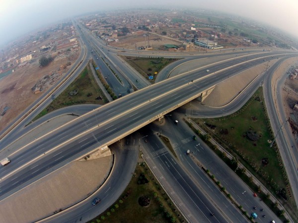
The Rawalpindi Ring Road
Impact
The much-anticipated Rawalpindi Ring Road is nearing 80% completion this year. This monumental infrastructure project is a game-changer for Bahria Town, particularly for Phase 8 and the Phase 8 Extension. By connecting Adyala Road, Chakri Road, and the GT Road, the Ring Road drastically reduces travel time to the New Islamabad International Airport and the motorways. Properties in the outer sectors of Bahria Town are already experiencing a price surge as the reality of this improved connectivity sets in.

Kachehri Chowk Remodeling and GT Road Beautification
Traffic congestion has historically been a hurdle for Rawalpindi commuters, but the ongoing Kachehri Chowk remodeling—featuring a massive network of underpasses and flyovers—is eliminating these bottlenecks. Coupled with the extensive GT Road beautification project stretching past DHA Phases 1 and 2 right to the entrance of Bahria Town, the daily commute for residents has never been smoother. These external developments make living in Bahria Town even more attractive, driving up housing demand and rental values.
Nearby Societies: The Regional Ecosystem on the Bahria Town Rawalpindi Map
Bahria Town does not exist in a vacuum. To fully grasp its market value, you must look at the borders of the Bahria Town Rawalpindi Map to see the surrounding real estate ecosystem. The strength of the neighboring societies directly reinforces the premium status of Bahria Town.
How to Use the Bahria Town Rawalpindi Map for Investment Success
If you are a serious buyer, how do you actively use the Bahria Town Rawalpindi Map to secure the best deal?
- Verify the Plot Category: Use a high-resolution Bahria Town Rawalpindi Map to check if a plot is a “category” plot. Is it corner-facing? Does it face a park? Is it on a main boulevard? Category plots command a 10% premium, and the Bahria Town Rawalpindi Map is the only way to verify these claims before visiting the site.
- Analyze the Topography: As mentioned earlier, the terrain is hilly. Use a topographical Bahria Town Rawalpindi Map to ensure you are buying a “levelled” solid land plot rather than a “filled” plot that dips into a depression, which will cost you millions extra in foundation construction.
- Track Commercial Proximity: The golden rule of real estate is location. Use the Bahria Town Rawalpindi Map to measure the exact distance from your residential plot to the nearest commercial zone. A 5 Marla house in Safari Valley that is a 2-minute walk from the commercial markaz on the Bahria Town Rawalpindi Map will rent out much faster—and at a higher rate—than one buried deep in the residential lanes.
Conclusion
The era of blind investing is over. In the highly competitive, fast-moving 2026 real estate market, having access to accurate, up-to-date data is paramount. The Bahria Town Rawalpindi Map is not just a piece of paper or a simple image; it is a dynamic blueprint of wealth generation, urban planning, and future infrastructure.
Whether you are tracking the final alignment of the Rawalpindi Ring Road, hunting for a high-yield commercial plaza in the Business District, or looking for a safe, low-budget entry point in the Phase 8 Extension, the Bahria Town Rawalpindi Map holds all the answers.
By understanding the geographical nuances, the phase-by-phase development status, and the surrounding regional ecosystem, you empower yourself to make secure, highly profitable real estate decisions.